ABOUTDEVELOPERSRESOURCES
|
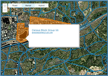
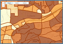
SpatialStream® Data Solution: Census BoundariesCensus Boundary data is ideal for spatially enabling and displaying demographic data, a must-have for mapping solutions today. The SpatialStream® Content Library makes it easy to integrate census tract, block group, and block boundaries into your spatial application and link those boundaries to demographic or custom data. With SpatialStream® you can add nationwide census boundaries in mere minutes, and use them for advanced mapping functions such as data aggregation, trend mapping, and data linking. Integration through the SpatialStream® web services is simple and easy, and you're relieved of data maintenance and update tasks.
Reliable and current geodata is the new expectation for today's location technologies. Click on the links below to learn more about how SpatialStream® can help you add valuable data to your mapping application.
|